Thursday, June 18, 2015

Bye-Bye Bill


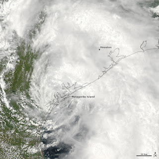
Tropical Storm Bill captured by a NASA satellite as it makes landfall near Matagorda, TX June 16, 2015

As tropical systems go, Bill wasn't the worst Southeast Texas has seen, but it did leave a mark. If you've lived in the region for any length of time, you know the difference between a hurricane and a tropical storm. I describe it this way: a hurricane is like a traveling evangelist, it blows in - blows up and then blows out. A tropical storm is like the neighbor who comes over to ask for a cup of sugar but ends up an unwelcome dinner guest. As advertised, Bill was a rainmaker and as is the case with fickle tropical systems - some received more than others.

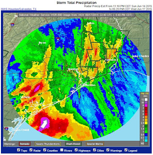
Here is a look at the rainfall totals estimated by radar from Bill:


The bullseyes of red and purple occurred far west of Houston in Wharton and Colorado counties where over 5" of rain fell. Similarly high amounts fell in Liberty, San Jacinto, Trinity and Polk counties. While not that much fell in Houston proper, there was enough to temporarily close some streets.

As the storm pinwheeled up into north Texas and Oklahoma, dumping flooding rains there as well. Even though the storm is exiting the state, the threat for more flooding isn't over. Runoff into the Brazos, Trinity and Colorado rivers could cause flooding later in the weekend. Additionally, there is a flood threat across the Ohio River Valley as Bill's remnants head there Friday and Saturday.

The second named storm of the season was also the second to make landfall. That hasn't happened since 2006. Hopefully, the forecast of El Nino disrupting the rest of the season will hold and residents of Texas will get a break.
Sunday, June 14, 2015

Bracing For Bill


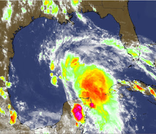
All eyes focus on the Gulf of Mexico as an area of low pressure is getting more and more organized. It is very possible that this will become the second named storm of this season. Bill will likely remain a tropical storm, but residents along the Texas coast should remain on high alert. After the wettest May on record in many places, Bill threatens to renew the flood threat. The rain could begin falling as early as Monday afternoon and might last through early Wednesday.

The air force reconnaissance planes, so-called "Hurricane Hunters" will investigate the system today and Monday morning looking for crucial information gained only by flying into tropical turmoil. They may indeed find a developing surface low pressure system aided by very weak upper-level winds. A weak high pressure ridge in the Gulf will tend to nudge Bill westward toward the Texas coast. A conglomeration of models has this opinion, although there is a wide spread as to the likely landfall location:


Most of the heavier rainfall in a tropical system falls east of the center. Therefore, the further west Bill heads, the worse it will be for Houston, Galveston and Lake Charles. If Bill heads closer to the Texas-Louisiana border, the greater the chance the flood threat ends up in central and southern Louisiana.

Here is the current thinking about the expected rainfall through mid-day Tuesday:


Anywhere from 3" to 6" are likely. Depending on the track of the storm, these rain bands could easily come in off the Gulf and repeatedly drench the same areas. This "training" effect could lead to flash flooding over an area hard hit by Memorial Day flooding. Residents should be alert and have a plan for getting to higher ground and avoiding low-lying areas that have a history of flooding.

Tuesday, June 9, 2015

Rain On The Horizon


The #NormanNumber™ in Houston for Tuesday June 9 is 8. Partly cloudy, hot and muggy. Little more than a stray shower likely. High: 93°.

The heat beat goes on for most of this week. Expect typical early June weather in Southeast Texas. By week's end, however, a change begins to develop as more widespread and heavy rainfall return to the region. 

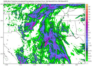
High pressure will strengthen across the Florida panhandle which will nudge a surge of Gulf moisture back toward the upper Texas coast. That should allow for showers and thunderstorms to develop. Here is what Saturday's map looks like:


At the same time, low pressure will begin to emerge from west Texas, setting up a kind of atmospheric "squeeze play". This could result in slow-moving storms, renewing the flood threat that plagued the state at the end of last month.


Tuesday, June 2, 2015

Finally Drying Out!


After a water-logged month of May, temperatures are set to head into familiar territory for June in Houston. The above shows the temperature trend for the rest of this week. Highs in the low 90s should be common; its only happened twice so far this year.

May rainfall tallied 14.17" inches in the gauge at Houston's official reporting location, making it the fifth highest ever. In all, there were only ten days when it didn't rain last month. A series of upper-level disturbances paraded through the Lone Star State spawning tornadoes and turning streets into rivers, but now the pattern is changing.

A high pressure ridge will settle in over at least the next ten days. That will help the mercury climb over 90 degrees and keep the rainfall threat very low. At best, a few isolated showers developing along the sea breeze may form, but these should be short-lived.