Friday, July 31, 2015

Triple Digit Days, Then Watching The Gulf


The heat is on as July comes to a close. Houston's official highs the last two days have been 100 and 101, consecutively, and just shy of a record each day. To end the month, we could see a triple-digit trifecta! The 1998 record of 103 looks safe, though.

However, believe it or not, a very weak cool front which is sliding through the Southeast could actually clip sections of east Texas. The main impact will be somewhat drier air wedging its way in. That could actually help a few isolated showers and storms fire up in the late afternoon. 

Also, as the front ends up in the Gulf of Mexico, some computer models are projecting that a weak area of low pressure could form. Right now, this is nothing to worry about. However, any time there is low pressure in the Gulf, it needs to be monitored.

Here is a depiction for Sunday:


Again, nothing to get too excited as it might just be low pressure that spreads rain toward southern Louisiana. Stay tuned, check back here and stay aware. Otherwise, just try to stay cool!


Saturday, July 25, 2015

Nothing But The Heat


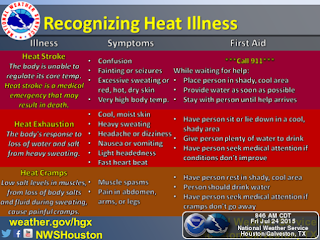
You've heard the saying - its not just the heat, its the humidity. It's true and it means you're at a higher risk of heat-related illness during the summer months. As the mercury rises, so does our internal temperature. Your body tries to cool itself naturally by sweating, but often, it's not enough. 

Those most at risk are the elderly, children, people who are overweight and those who are already ill. So its most important that these groups monitor the amount of time they spend outside. One way to combat the threat is to remain as hydrated as possible. Drinking plenty of water helps the body replenish necessary elements like salt and other minerals.

It will be difficult to avoid summer's heat though for the rest of this month. High temperatures will bump up close to 100 but with the added humidity in the air, the heat index will range between 100 to 105. While not high enough to meet the criteria for a heat advisory, it still could put you at risk for heat stroke, exhaustion and cramps.

Despite the heat of recent days, July 2015 in Houston hasn't been record-setting - yet. The average temperature is running about a degree above normal. On the current track, this could end up in the top ten warmest Julys on record.

Rain has been hard to come by as well - next chances for spotty, isolated showers won't return until early August.

Monday, July 13, 2015

Curiously...Claudette!


The circled spec in the north-central Atlantic ocean doesn't pose a threat to any part of the U.S., but Monday afternoon, the National Hurricane Center declared this tropical storm Claudette. 

The storm's origins come from weekend storms that moved off the North Carolina coast. They intensified and maintained a circulation with a maximum sustained wind of 50 mph, more than enough to get the Tropical Storm designation.

The current track shows it headed toward Nova Scotia very quickly:


The storm will likely become post-tropical by late Tuesday. 

Things are still quiet off the west coast of Africa and we're still weeks away from the start of the Cape Verde season. Stay tuned and stay alert. Claudette formed without much warning. Something similar could always happen in the Gulf as inland storms forming in Louisiana, Mississippi or Florida could drift that way. 

It's tough to make every headline for these kinds of posts have creative alliteration, but I'll try...


Thursday, July 9, 2015

July Weather In Full Effect


It's no surprise that summer's heat and humidity are in full effect in southeast Texas. It is July, after all. What is surprising is the continued flooding as storms form from the Red River eastward into the Ohio River Valley. A high pressure ridge depicted above is allowing temperatures to soar into the mid to upper 90s from east Texas into the Southeast.

A stalled front stretching from the mid-Atlantic back to the Red River is the cause of recent rains there. Eventually, the high will slide back toward Central Texas, giving some drying relief to northern neighbors. This is what the upper-level pattern looks like by Saturday:


Until then, the best chance for any rain in Southeast Texas remains isolated showers developing along the coast from the sea breeze. Depending on how far west the ridge shifts, there could be more widespread showers toward the end of the weekend. Here's what the short-range model depicts for rainfall (green) by Saturday:


Thursday, July 2, 2015

Heating Up and Drying Out


Summer's heat and humidity makes a comeback to southeast Texas. A ridge of high pressure depicted above should block a series of storms emerging out of the central plains. The predominant northwest flow in east Texas sends rainy weather into the Southeast U.S. A few rouge rumbles might make it through, but most should stay dry.

The high pressure ridge sends temperatures back into the low to mid 90s and the added humidity will make it feel like its over 100 degrees so, take it easy out there. This graph shows the "apparent" temperature (taking into account the effect of the added moisture in the air):


Right now, it looks like the pattern could break down in time for...you guessed it, the July 4th celebration. Currently, the day doesn't look like a washout, but its a bit too early to time the arrival of storms that day. best advice is to check back to this blog a little closer to Saturday for updates.