Thursday, March 26, 2015

Cooler Weather Coming


While not a freeze, it will get cooler across the Lone Star Friday morning. The cold front that sparked the severe weather in the southern Plains and Ozarks Wednesday is pushing through Thursday, sparking a few gusty thunderstorms along the upper Texas coast. By mid-day, breezy northwest winds move in delivering the cooler air. Clearing skies Thursday night will allow the temperatures to slip below 40 in many places. Nowhere near the 1955 record of 31 in Houston for Friday, though.

Don't worry, this winter left-over won't last longer than pizza in the frig. Back to the 80s by Sunday.

Tuesday, March 17, 2015

Cloudy, warm weather continues


The Norman Number for Tuesday March 17 in Houston is 6. 

Hope you enjoyed Monday's glimpses of sun. There will likely be less of that as the week continues. High pressure in the northern Gulf allows a steady southerly flow to return to southeast Texas. That will mean more humid days ahead and could allow for some rain to return as an upper-level disturbance moves in from the Hill Country. This has been a recurring theme the past few weeks and it looks like the beat goes on. 

Additionally, Tuesday and Wednesday morning will begin with widespread fog which could greatly reduce the visibility, especially along the coast. 

As for the rain,its looking more and more like the bulk of the steadier, heavier rainfall will be across north Texas, but a few showers are possible in southeast Texas. Here's what the Monday nigth models are projecting for 7 am Wednesday:


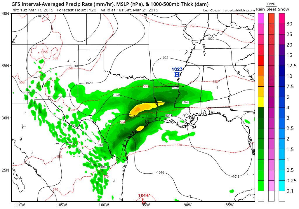
By the weekend, another system moves in from the Hill Country, making for a soggy first weekend of Spring:


This is the kind of weather pattern that could bring severe weather down the road, if it persists.


Thursday, March 5, 2015

Ok, Who Left the Back Door Open?!


The Norman Number in Houston for Thursday, March 5 is 3. Morning rain ends by mid-day, but temperatures fall all day and gusty 30 mph winds howl.

Brrr - winter's BACK! The strong cold front that swept across the Lone Star state yesterday bringing icy conditions to north Texas has slashed temperatures today. We'll barely get above 40° for a high temperature and there will even be some lingering rain early in the day. Even after the rain quits, clouds and windy conditions linger. In fact, you'll need to hold onto your hat as gusty north winds could blow as high as 20 to 30 miles an hour.

This won't be a short-lived period of cold, however. We should see several mornings close to freezing Friday and Saturday mornings. Highs won;t get back above 60° until the middle of next week. While we avoided ice and snow, rain returns quickly to the forecast with a good chance for a soaking by Sunday:


But, of course, it IS rodeo season...

Wednesday, March 4, 2015

This Spring Feel Won't Last Long


The old adage, "March comes in like a lion" will certainly apply to southeast Texas weather the next few days. Southerly winds continue to keep temperatures in the 60s and 70s today. That same muggy air fuels showers and thunderstorms that will form along a fast-moving cold front sweeping in from the north. As the front moves into north Texas, it brings the threat of ice to Dallas. No threat of that closer to metro Houston, although up around Huntsville or College Station, there could be some sleet early Thursday.

It is a real cold front, however. So get ready to trade your rain gear for winter coats! The warmest part of Thursday will be daybreak, when it could be around 45°. Steady north winds drive the mercury into the upper 30s under cloudy skies by the afternoon!  We'll shiver close to the freezing mark by Friday morning.

The Norman Number for Wednesday, March 4 in Houston is 7. Again, before the big change, it'll be a warm, breezy and balmy day with mostly cloudy skies early giving way to some sun by afternoon. The threat for rain doesn't arrive until late in the evening.


Tuesday, March 3, 2015

Headed To The Rodeo Tonight? - Pack The Rain Gear


Looks like fans headed to enjoy the first of several nights of calf-scramblin', chuck-wagon racin' and mutton-bustin' will need to prepare for rain. It likely won't really get that soggy until the early evening. Most of Tuesday will be deceptively nice - kind of breezy and balmy actually, as temperatures soar close to 70°:


The same southerly winds that will boost the mercury will also pump abundant Gulf moisture into southeast Texas, prompting the showers. In fact, it looks like the rain will continue into Wednesday as well. Then, something really odd will happen. Wednesday's rain likely changes over to a brief period of sleet and freezing rain early Thursday morning. An arctic blast is set to descend in from the central plains beginning Wednesday night. Our northern neighbors from Waco to Dallas will again deal with an icy mess. This taste of winter will be a little different than the past two - it'll come with very gusty winds. Here's a computer projection of conditions Thursday morning:


This is a dynamic situation that bears watching, so check back here for updates.

In the meantime, the Norman Number in Houston for Tuesday, March 3 is 6: